The Settlement Period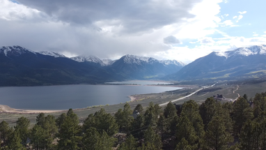
At the base of Mt. Elbert; in Lake County Colorado, you will find a picturesque valley with two massive glacial lakes puddled in the valley below the mountain's peak. This nearly deserted area is referred to as Twin Lakes Colorado and sits outside of the town of Leadville. Legends dating back to the 1800s say the lake has no bottom and has deep holes that people were lost forever in. The natural bodies of water were eventually altered by engineers, connecting the two lakes. A bit later, a 135-foot-high dam was constructed in 1896.
This is a very natural progression for freshwater supplies. Often, this progress threatens not only wildlife but the livelihood and living of the surrounding residents. In some instances, entire cities were flooded and to this day the spires of cathedrals and brick buildings can be found at the bottom of massive bodies of water, such as the 11-mile reservoir in “Eleven Mile State Park”. In this instance, the rising water threatened a thriving and growing resort on the Southside of the lakes.
The thirst for water was emanating 18 miles away in Leadville. As the city grew residents became eager to escape the noise and smoke of the bustling city. Vacationers began flocking to the peacefulness of Twin Lakes. 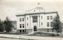 Dayton Court Hours Dayton Court Hours
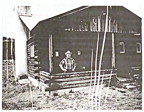
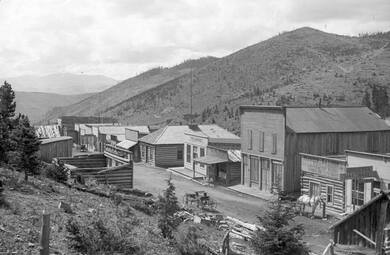
In the mid-1860s, on the north side of Twin Lakes, a mining camp called “Dayton” once existed. For a brief time, the camp served as the county seat of Lake County Colorado. The mining camp attracted some of the earliest visitors to the area. Some of the more well-known visitors were Wheeler’s and Hayden’s geological surveys. Who proved the lakes were formed by pre-historic glaciers. Additionally, the famed photographer and painter William H. Jackson stayed for a time producing captivating paintings and photos of Twin Lakes.
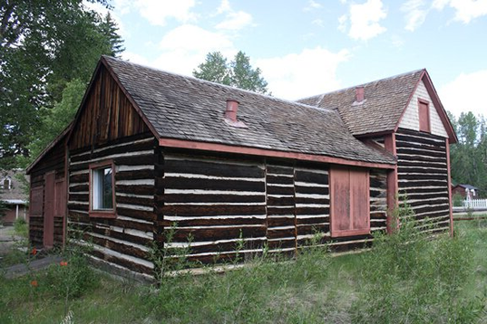 Remains of Dayton Remains of Dayton
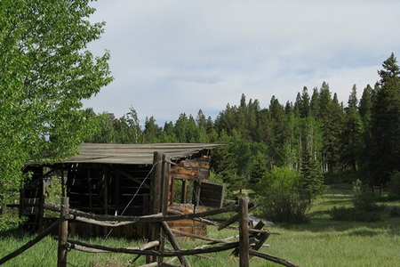
Dayton blossomed into a budding town, boasting a Masonic Hall, post office, general store, courthouse, multiple hotels, many homes, and a milliner’s shop (or hat maker). Notably, a common feature of an early American town was absent, there was no church. Although the Masonic Hall was used by traveling priests for periodic sermons. The city was described as being hopeful for the future because its neighbor; Oro City, had mostly run out of surface gold and was losing population at an alarming rate. By 1866 Dayton had overtaken Oro City and was voted to be the county seat of Lake County. The growth and optimism of Dayton were short-lived. This is because the money that the new residents of Dayton had hoped to use to develop the mining district never came. With a lack of investment, the residents of Dayton took to working the gold lodes near Twin Lakes with only picks and shovels. These efforts were fruitless, and the mining community moved on to the next settlement, Granite Colorado. By 1868 Dayton was nearly abandoned. The commissioner of Granite decided to raise $500 to move the Dayton courthouse to Granite. For over a year, laborers moved the structure 10-miles south, brick-by-brick, where it remains today. At this time the post office recognized Granite as the replacement for Dayton.
 Remains of Dayton Remains of Dayton
The derelict village of Dayton remained abandoned through the 1870s. A vacationer from 1871; Annie B. Schenck wrote of her visit in a journal entry, saying “The miners are a queer impulsive set of folk. If a settlement of them find they are making some three or four dollars a day when somewhere else they can make seven or eight, the whole lot of them will pull up stakes and leave for the richer mines. Sometimes they are obliged to desert their town when the mines give out. This was the case with Dayton — the place was started by miners who dug for gold … and when the mines ceased to yield, they were obliged to go off and seek their living elsewhere. We rode among the houses, of which there were twenty-five or thirty — all log cabins with mud roofs. It was just at dusk and the place looked most dismal and forlorn in that light. One can hardly imagine anything more desolate than these abandoned villages”.
 Remains of Dayton Remains of Dayton
The cabins and shops of Dayton remained empty for the rest of the decade. Eventually, the surviving portions of Dayton were replotted and moved closer to the roadway that leads to Leadville. At the time there were ten other towns with the name of Dayton and the US postal service decided the new village would take the name of its most well-known feature, Twin Lakes. Some 196 residents still call the Twin Lakes village home, as of the 2020 Census.
Despite the lack of a bustling town center, the mild climate and breathtaking scenery continued to draw visitors. In an 1876 issue of the Rocky Mountain News, a visitor identified only as “R.E.E.”, boasts about the area's offerings, saying “The lakes are an excellent place of resort for invalids and pleasure seekers. Trout fishing, hunting, and beautiful scenery offer great inducements to those who have time and money to spare, and who delight in the wild sports.”. The Growth of A Marvel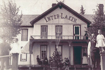
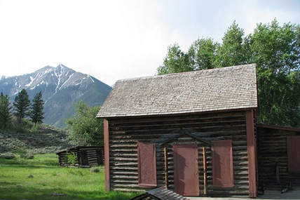
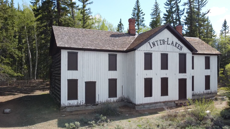
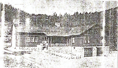
Thankfully an aspiring entrepreneur saw an opportunity to offer more than camping and abandoned bunkhouses to visitors. He set out to create a lakeside destination. Interlaken, originally named “Lakeside Resort”, was built in 1879 by John A. Staley and Charles Thomas. It started with humble beginnings, and eventually boasted a two-story hotel. The hotel was a popular mountain destination for people on the way over independence pass or nearby mining communities. The miners made their stop, and the hotel rang with laughter and music. Towering Pines sat on top of lush, carpeted lawns of bluegrass. The lawn was dotted with sparkling water fountains, gardens, and native flower beds that bloomed throughout the summer. It was designed to respond to and enhance the picturesque mountain setting.
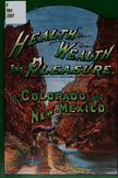
The 1870 book, “Health, Wealth, and Pleasure in Colorado”, described the resort after Staley’s improvements; saying, “The hotel and boarding-house accommodations are good and will be rapidly extended. During the summer months, there is an almost constant round of society picnics and private pleasure parties coming down to the lakes from Leadville, so that nearly every day brings a fresh influx of visitors, enlivening the resort, and dispelling all tendency to monotony. Twin Lakes is the highest of all the popular Rocky Mountain resorts and furnishes an unfailing antidote for hot weather.”
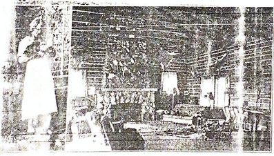
Only 4-years after opening; in 1883 it was purchased and expanded upon by a mining millionaire from Leadville named, James V. Dexter. This was not his first foray into the resort industry. Other memorable resorts he constructed include Evergreen and Idlewild Lodge. The Interlaken resort was one of his most ambitious undertakings. After adding 2,000 acres of land, a dance hall, a log tavern, a 16-horse stable an icehouse, guest rooms with panoramic views, servant quarters, and a couple of hexagon-shaped privies that were considered state-of-the-art restrooms. This is because each of the six sides was reserved for specific guests of the hotel (accentually they were private restrooms). Additionally, they featured seldom seen amenities, such as leather seats and fragrant flowers.
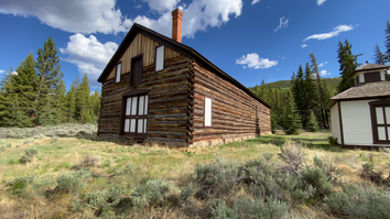
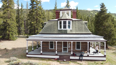
In the mid-1890s Dexter constructed a personal cabin that spared no expense and is one of the most interesting structures on the property. Dexter’s “cabin” more resembled the mansions of the time, featuring imported wood trim, open verandas, gabled dormer windows, a mansard roof, and is crowned with a glass-enclosed cupola with views in all directions. In its time the cabin was outfitted with, elaborate rugs, maple furniture, and high-end décor. A décor that was influenced by Dexter's fondness for playing poker and hunting. Creating a deep, rich tone, that demonstrated Dexter’s lavish lifestyle. The building's architecture reflects Dexter’s nautical interests yet somehow does not seem out of place in the Rocky Mountains
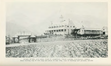
Near Dexter’s Cabin, in 1895; a man named, John F. Campion built a private summer home for his bride, that aimed to surpass Dexter’s cabin. Similar to Dexter, John also made his fortune in the Leadville mining industry, as well as, Colorado sugar beets, among other businesses. His ownership and operation of the most productive regional gold mines; the Little Jonny and Ibex mines, is what catapulted Leadville into the second-largest city in Colorado. His Twin Lakes villa was large enough to accommodate a bowling alley, electric power plant, shooting gallery, and dais stage (or playroom).
The Campion family used the stage often. Because in those days people were fond of amateur plays or as they called them “theatricals” or “charades”. As soon as you entered the door you were greeted by a series of costumes, encouraging guests to put them to good use. 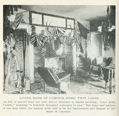
Mr. Campion was described by his childhood caretaker and long-term housekeeper; “Mrs. Edwards” in a 1959 interview with Colorado Magazine as being “a very amusing man” who “had nicknames for his friends and family”. She went on to say that Mr. Campion referred to his wife as “Flannelmouth” or “Pokey”. Other terms of endearment he used included “Fatty” for his daughter Hellen.
The villa represented the Campion family’s whimsical nature. For example, the foyer contained a large wood carving of a bear that was used as a hat rack, where Mr. Campion's hat was often perched in the mouth of the bear. Their Irish roots were proudly represented in a rough stone fireplace with a carved Gaelic saying, “Caed Mille Failthe”, meaning, “One hundred thousand welcomes”. The décor reflected their love for Swiss culture, blended with their Celtic traditions. For example, the largest painting in the living room was of the Lion of Lucerne monument in Lucerne, Switzerland. 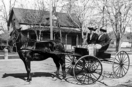 Road Wagon Road Wagon
Mr. Campion would drive his two-seat, road-wagon to Leadville Monday morning to his office and would return Friday evening. Occasionally, Mrs. Champion and Mrs. Edward would accompany him part way and walk back. Mrs. Edwards recalled one of these trips were they chased by “a big black cow”. Saying, “A few cattle were grazing loose by the road. The cow had probably never seen a woman... We all ran for our lives and made for a dilapidated outhouse with a door hanging on one hinge. We got in and held the door while the cow took out her anger on the door. We remained there for some time before the animal got tired and we were able to get out and make for the fence and home ”.
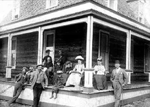
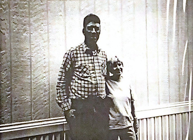
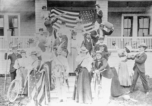 Campion Hotel Guests Campion Hotel Guests
At a certain point, Mr. Campion learned that the lower lake was to be used for irrigation and his home would be submerged by water. He promptly sold the property and left the operations to his former housekeeper, Mrs. Edwards. For a time, she put the four-teen lavishly appointed guestrooms to good use by running the home as the “Campion Hotel”. Saying in 1959, “if any of the people who were guests at Twin Lakes are alive, they can tell you of the good times at the Campion home… Some of the young men went off to the Spanish War and never returned. I imagine that all these people have passed on and that I am the only one left who remembers Twin Lakes when it was the center of social life in the Leadville area”. Before the irrigation project could be completed the Campion Hotel burnt to the ground. Leaving behind only the memories of the Campion family and hotel patrons.
 Lakeside Bard Lakeside Bard
Meanwhile, Lakeside Resort continued to improve. Its barns and stables had become like nothing else in the region, featuring a tack room, hayloft, 16-stalls, and carriage storage. Another barn: that has fallen to ruin, accommodated milk cows, chickens, and additional food storage.
At this juncture, the resort received its new name, “Interlaken”. Named after a traditional resort town in the mountains of Bernese Oberland, in central Switzerland. This is especially fitting because this region of the Rocky Mountains is commonly referred to as the “Switzerland of America”. 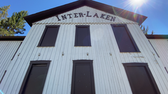
Charles Dexter’s improvements created a world-class resort in the wilderness. His goal of elevating the resort to a higher class of clientele was achieved. His property rivaled the internationally recognized Broadmoor resort and the town of Aspen Colorado. The resort possessed some of the best facilities of the time and grew to become an extremely popular stop for well-to-do travelers passing through nearby, towns (Leadville or Aspen).
Interlaken became a destination rather than a passing stop. It was certainly the most expensive hotel in the area, charging up to $4 a day for access to the famed facilities. Flocks of people came to fish, horseback ride, picnic, play croquet, or cruise across the lakes in steam-powered boats. Visitors often relaxed in the tavern or pool hall. Where they were delighted by billiard tables with inlaid rare woods or ivory and gourmet multi-course meals. Every week during the summer the Leadville Orchestra would play in the hotel pavilion, where Civil War-themed oil paintings covered the walls. The book “Health, Wealth, and Pleasure in Colorado” said; “Even in midsummer flannels are necessary articles of apparel, and thick woolen blankets are indispensable at night”. In the early years' during summer guests journeyed by train to Granite; where they boarded a side-seated platform wagon that carried them 5-miles around the lake to the Southeastern side of Twin Lakes. A boardwalk existed to escort visitors from the wagon stop to the front porch of the hotel.
During the winter months, activities, such as skiing, skating, and sleigh riding were common amusements. As ice blanketed the lakes, teams of horses drew sleds with visitors across the frozen lake. The relative luxury coupled with the rustic mountain setting proved to be a powerful draw to wealthy families year-round. However, as we know the good times did not last… The Decline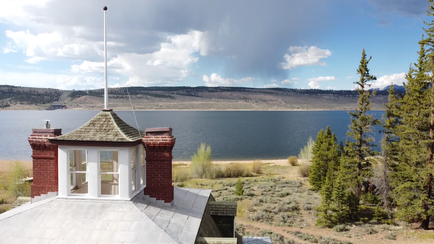 View from Dexter's Cabin View from Dexter's Cabin
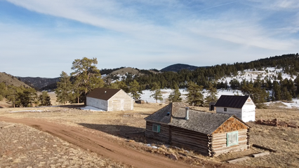
Interlaken was regarded as Colorado’s most beautiful resort through the late 19th century. Dexter’s Resort successfully operated for 25 years before it began to fall out of favor after his death in 1899, eventually closing in the early twentieth century.
The first blow to the growing community was the addition of the dam connecting the two lakes in 1896. This change raised the water levels and destroyed the only roadway to Interlaken Resort. Despite being accessible by boat, this alteration caused a portion of the water to become stagnant and much of the lake was too shallow to enjoy. This change brought with it mud, mosquitoes, and an outbreak of the disease malaria. At the time this disease was the leading cause of infectious death in America. Once the word of the outbreak got out, the majority of the guests opted to protect themselves from the risk of exposure and no longer attended the resort. The flow of visitors slowed to a trickle, after 17-years of growth and 25 years of operation; the structures fell to dereliction, and this eventually led to the closure of the property by the state of Colorado, in 1950, 71 years after its founding. 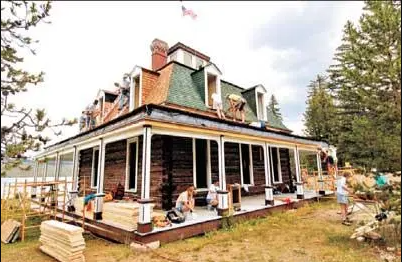 Interlaken Restoration Interlaken Restoration
In the early 1970s plans to build a higher dam and expand the reservoir threatened to flood and submerge many of the abandoned structures. Fortunately, the site was placed on the National Register of Historic Places. In 1979 the Bureau of Reclamation began to record and stabilize the structures. Giving the area a new name; “Twin Lakes Historic District”.
Once the dam was complete; to avoid the rising waters, several of the structures were lifted and moved 150 feet to higher ground. The structures remained derelict in this position for another 25-years. Between the first abandonment and the relocation, almost a century had passed while the resort and its buildings were left abandoned and deteriorating. In 2001 Colorado Preservation listed Interlaken as one of the most endangered places in Colorado. That same year, a group of local volunteers began an effort to stabilize and restore the resort’s structures. The work began in 2004 and was completed in 2008 after 4-long years of hauling materials across the lakes. A New Life for Interlaken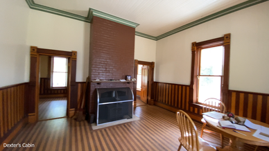 Dexter's Cabin Dexter's Cabin
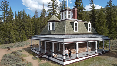
Today some of the resort’s structures remain standing and hikers are invited to explore the site and tour themselves through the preserved buildings. This tour includes the six-sided privy, granaries, cabins, and hotel. One of the most well-preserved buildings; Dexter’s cabin, remains open to the public and free to tour inside and out. If you choose to visit, please enter the cabin through the front door (facing the lake), and please be sure to latch the door when you leave. The masterfully restored interior features one-of-a-kind wood floors, intricate doorknobs, a wood-paneled bathtub, and original walnut woodwork. Backcountry hikers are welcome to view the restored interiors and climb to the top where they enjoy a panoramic view of the lake from the cupola (watch your head on the way up). At one time the stable was open to the public and featured a group of old carriages and other relics. Unfortunately, this is no longer open to the public and has been cleared out.
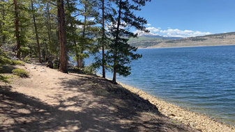
The resort site can be accessed by boat or a hiking trail that starts at the southeastern end of the larger lake. Camping is not permitted in the area. For a safe and suitable campsite please visit the Leadville Ranger District Campgrounds for a list of choices.
The hike consists of an undulating wooded path that is perched on the lake's edge and smells of wild sage and fresh mountain water. The total round trip is 4.7 miles, with an elevation gain of 760 feet. It’s a great hike for families or groups who are looking for a half-day hike with a lunch at the historic Interlaken Resort. The porch surrounding Dexter’s Cabin is a picturesque place to enjoy a picnic and the breathtaking scenery surrounding the historical structures.
Intrested in volunteering to preserve Interlaken? Visit Friends of Twin Lakes.com or email: [email protected] to learn more!
Photos of Interlake & Twin Lakes
0 Comments
Deep in the Rocky Mountains, you will find the lush and fruitful San Luis Valley; home to the small city Alamosa, which is an agricultural hub in South-Western Colorado. This area is home to some of the best stargazing on the planet. The views are so spectacular that Alamosa has taken measures to protect its view of the cosmos by becoming a “Dark Sky” city. Which is a series of measures taken by the community to limit the amount of light pollution that is emitted from their city. This makes for a dark city at night, with vivid views of the stars above. This was a fact I was unaware of when I arrived in Alamosa late one evening. I hoped to find a grocery store before I made my way to a local hotel, but thought they were all closed due to the lack of exterior lighting. Fortunately, I noticed people still flowing in and out of a local store, despite there being no parking lot lights or exterior lights; outside of a few downward-facing lamps on the side of the building. It was eerie until the local store clerk explained to me how a Dark Sky city works. Once explained, I was enthusiastic about the idea, despite the dark alleys and shady parking lots.

I came to visit the otherworldly Great Sand Dunes National Park, which was amazing. However; I found myself captivated by the locals' enthusiasm for stargazing and UFO spotting. After all the San Luis Valley is the highest alpine valley on the planet and, depending on who you’re asking, it’s a prime spot for witnessing paranormal activity, such as mystical portals, UFOs, and other strange occurrences. Much of the sightings surround a remote section of Highway 17, or as the locals refer to it, “The Cosmic Highway”. And in case this fact was lost on you, it is hard to miss the little-green-men-signs that dot the roadway and make you aware of the coming attraction. Whether you’re an avid believer in visitors from other worlds or an avid skeptic, it doesn’t change the fact that there’s been a lot of strange things reported in the San Luis Valley. These happenings and sightings stretch from South-Western Colorado to Northern New Mexico and the stories date back to the Spanish Conquistadors expeditions into the area. Some call the San Luis Valley “The Bermuda Triangle of the West.” The sprawling expanses west of the Great Sand Dunes and its preserved lands are interrupted only by Highway 17. This vast emptiness, scored only by the roadway, has numerous sightings. Ranging from strange lights to otherworldly aircraft, the sheer amount of reports is notable, regardless of what side of the UFO debate you’re on.
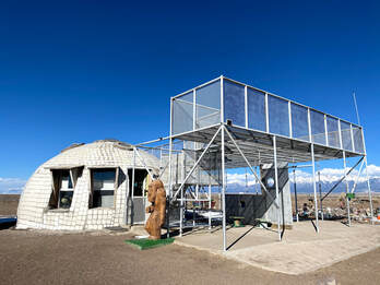
If you were to follow highway 17 North, just outside of Alamosa you will find a small burg called Hooper. Which is home to what is arguably Colorado's most unique roadside attraction, the “UFO Watchtower”. Which is a place that invites curious minds and extraterrestrial seekers for a chance to spot a UFO or alien. Allegedly this location is a frequent host to numerous UFO sightings, Which is likely thanks to Alamosa’s vast and unfiltered view of the night’s sky.
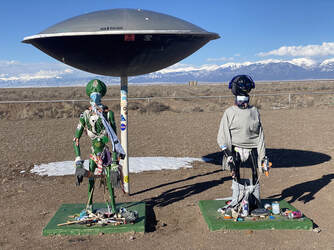
The UFO Watchtower in Hooper consists of a brick dome and 10-foot high metal rafters. Which is flanked by a gigantic alien-themed folk art which consists of thousands of trinkets that have been left by visitors over the years. There is one rule for placing an item, it must be an item that has use or has some significance to you. The art piece sits on what is believed to be a portal to another dimension. Admittedly, we are getting into territory that is somewhat hokey, but would you expect any less from a good ol’ fashioned roadside attraction? (more on that later) 
The proprietor of the watchtower; Judy Messoline, tried her hand at cattle ranching with little success. Saying, “I struggled with cows for four and a half years, because they don’t eat sand very well, and had to sell the herd”. A local farmer suggested that Judy build a UFO watchtower to better spot the otherworldly craft that regularly flew over the area. Admittedly, Judy opened the UFO watchtower as a joke, after moving to the valley over two decades ago and hearing the strange stories from her neighbors. However; after experiencing over 30 encounters herself, the watchtower has taken on a renewed purpose. One that is much more serious than mere roadside entertainment. She has crafted a place where people can gather, mingle, camp, and a place where “people don’t get made fun of” for talking about these types of things.
For more than 20-years and over 30,000 visitors later, the UFO Watchtower has evolved far past its original roots. It’s a place where people of all walks of life are comfortable sharing experiences that would be considered unbelievable anywhere else. The UFO watchtower exists to affirm believers and entertain or amuse everyone else. It’s a perfect blend of roadside attraction and a like-minded gathering place. Though Messoline still tries to keep a sense of humor; for example, providing a separate guest sign-in book for extraterrestrials (and several visitors have claimed to be aliens).
I was fortunate to be one of the first visitors since the watchtower reopened after the covid-19 pandemic showed improvement. During my conversation with Judy, she expressed concerns about being able to stay open and sustain after the closure. However; this was the quiet before the storm as the watchtower has become very busy with "post-pandemic" travelers. An added boost in notoriety came from people who, during the lockdown, found an old 2013 Vice news article that featured Judy and her attraction. The reemergence of this article, coupled with pent-up travel has made for a banner year at the attraction. 
Since opening in 2000, there have been 231 reports of visitors from other worlds (30 of which Judy witnessed first-hand). Meaning she averages seeing one sighting each year, since moving here in ‘95. Messoline described one such sighting in 2017, saying; “The closest one was between here and the mountains. It was narrow and long and zipped across the sky… we had over a dozen people here who saw it”. This is just one of the countless sightings that have accumulated, some of which Judy documents on her website; which is ridiculously outdated; but comes with a certain late 90’s charm that I hope it never loses.
The website also goes into detail about what I referred to earlier as “folk art”. However, Judy and a group of psychics think it is much more than art and refer to it as the “Healing Garden”. Numerous psychics have affirmed a belief that two “beings” reside in the garden and exist to protect a series of spinning vortexes... (admittedly, I have no clue what that means; but if nothing else it is fascinating folklore). Because of this Judy requests that people leave something behind to “receive good energy” from the vortexes/beings. Again, the item cannot be just a random piece of garbage, it must be an item that has meaning to you or is useful. 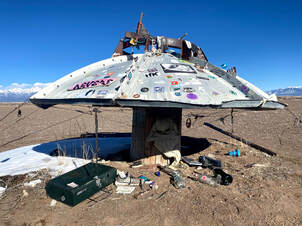
As a casual visitor, the Healing Garden offers you a feast for the eyes. Ranging from the mundane; such as pens, lighters, Altoids containers to wildly creative items, toys, photos, and thoughtful mementos. I spent over an hour exploring the maze to find the right place to put a memento of my own. Judy explained that many of the larger items were donated by enthusiasts and locals; such as the satellite dishes or statues. Although she did not mention it during our conversation, her website has a list of requested items. The list includes the expected items; chairs, picnic tables, or playground equipment and is packed with unexpected, and somewhat humorous items; like moon rocks, lasers, and jet packs.
Eventually, I made my way to the dome of the watchtower which acts as a mini-museum/gift shop. Where you can pick up a copy of Judy’s Book, “The Crazy Lady Down the Road” or more casual souvenirs; like Alien googly eyes. She is happy to help guide visitors through a plethora of binders, photos, and documents that Judy has collected over the years. I could have spent hours pouring through the handwritten accounts, photos, and news cuttings.
I left this place surprised just how much fun it was and I appreciated the roadside attraction that Judy Messoline has crafted over the past 21-years. If you find yourself in the San Luis Valley, I highly encourage you to visit The UFO Watchtower. You can visit from 10:00 am - 4:00 pm; admission is $5 per car or $2 per person and you can camp for only $15 per tent! Places like this are becoming rarer and rarer as the roadside attractions of the past close one by one. Help keep this attraction open and enjoy a stay at the UFO watchtower! UFO Watchtower Photos: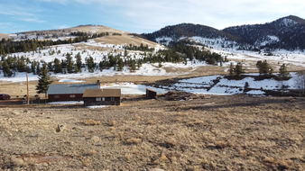
Today I would like to share with you a hidden gem. One that is nestled at the foot of Mount Baldy, in a lush meadow. It is so tucked away that unless you had directions or knew the way you would not know it exists. I am referring to 31 Mile Ranch, which is a privately owned historic site and rental property. As you enter the property you are greeted by a striking Duch-colonial barn set against the backdrop of a sun-soaked valley and a modern cabin with all the high-tech amenities you could need. I had the pleasure of staying on the site and was fortunate to be able to speak to the landowner, who provided us a wealth of information about the property’s history and its potential future.
The ranch has a sorted tale complete with debutants, cowboys, and heartbreak. One that is well documented in the local newspaper and by historical records that the property owners have kept and passed down as a family heirloom. I was fortunate to be granted unprecedented access to these documents and look forward to sharing the story of 31 Mile Ranch.
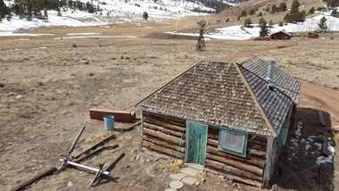
The first mineral rights records on the property date back to a claim that was made in 1883. The original settlers continued to renew their mineral rights until 1942. But no major mining operation was ever developed on the land. Rather a 600-acre plot of land was homesteaded by Charles V. Corliss on June 16th, 1921. 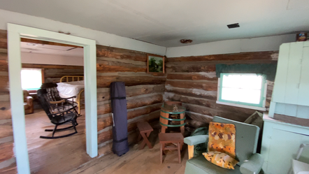
To the best of recollections, the two-bedroom log house that stands today was built in the 1880s by the original mineral rights owners. A large 5-bedroom log house was built in the early 1900s by ranchers who leased the area from the government. The architect who built the windmill and house was an artist and builder from Colorado Springs named Benjamin Lefkowsky. The windmill that we see today is all original except for one replaced blade. It once pumped water into a tank inside the attic of the log house, supplying it with running water. The attic of the home used sawdust as insulation and unfortunately, in 1950 a hot stove pipe caught the sawdust on fire and the house burnt to the ground. Today we can still see remnants of the stove that caused the fire amongst the foundation of the home.
Before the house burnt; in 1925, Barbara Monell-Glaze purchased the ranch from Charles V. Corliss and constructed the 5-bedroom log house. Barbara was known to be a very social lady, who held dance parties once a month on the top floor of her barn. Barbara's father: Ambrose Monell, was very wealthy as he was the president of the International Nickel Co and a director of several important banks. Her father afforded her a lavish lifestyle with a $1,000 a month allowance. Which in today's currency would equate to over $15,000 a month. But Barbara shunned the glitz and glamor of her father's lifestyle in New York City, she was a self-described “Horse Woman”. Hence why she made her home at 31 Mile Ranch.
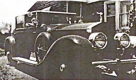 Barbara's Rolls Royce & Home Barbara's Rolls Royce & Home
Her love of horses was a lifelong passion. She had won many ribbons in both the Western and Southern horse circuits. She described it as her favorite pastime; however, others said it was a full-time love affair. Before becoming an accomplished equestrian, when Barbara was only 16 years old, she completed a 2-mile swim in Newport. Astonishing the doubt-filled Newport elite.
Though she was not all grit-and-spit and occasionally used her wealth to indulge her decadent side. For example, when she was not enjoying her horses, she was known to drive around the county in her Rolls Royce convertible. And before moving to the ranch she lived in an exclusive Colorado Springs Resort, the Broadmoor; but more on that later. 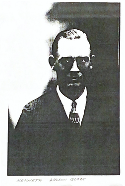 Kenneth Glaze Kenneth Glaze
ile frequenting the local rodeo she in-passing met Kenneth Glaze who was a rancher and rodeo performer. But they were not properly introduced until she needed a bridal (for a horse) repaired, and she found herself in Colorado Springs at Kenneth’s harness shop. During this exchange, she discovered that Kenneth was an expert horseman and romance bloomed rapidly. Interestingly, this was not her first time in his shop. Before moving to Colorado Barbara visited and brought her dogs with her. Not realizing that her dogs were required to be on a leash in the city of Colorado Springs and as a result, she found herself in Kenneth's shop. Their chance encounters were almost serendipitous as if it were a match made in the heavens.
The local paper described Kenneth as “a cowpuncher, wild west performer, and harness shop proprietor.” They went on to say, he was the picture of “physical perfection, six feet, and one-quarter inches… weighing 176 pounds. He is of the type that would fit well in a ranch picture… he is of the great brand of westerners.” Kenneth was only 13 years old when he moved from Illinois to Colorado, with his parents. He rode the ranges of South Park County for 7-years. Until he decided to drive his herd of horses 66 miles away, to Colorado Springs. Where he sold the horses and used the proceeds to purchase his harness shop. Where he remained for another three months before meeting Barbara Monell.  Barbara & Kenneth's Apartment Barbara & Kenneth's Apartment
For a time, the couple resided in a modest first-floor apartment in Colorado Springs. The Colorado Springs Gazette peered its nose down on Barbara by saying she had undergone a “metamorphosis from gilded lobbies and refined drawing rooms to a three-room apartment and preparing her own meals with a grace that only a newlywed can muster”. However, their long-term plan was to wait until spring and move to “a ranch in Southwestern” Colorado. As Kenneth put it, he was “enthusiastic over the prospect of a free and untrammeled life in the open”.
 The Broadmoor Resort The Broadmoor Resort
Their relationship was watched closely by residents of the fashionable and high-end community, the Broadmoor. This is because before moving into their simple Nevada St. apartment, Barbara lived in the Broadmoor, where suiters fell upon themselves to catch her eye. She only stayed for four months at this posh location and her quick departure led to all sorts of speculation. However, the stay was always intended to be short-lived, as she was recovering from a surgery that she had undergone that fall. At the recommendation of her mother, she decided to recover in Colorado; however, to her mother’s dismay, she loved the area so much that she decided to stay permanently.
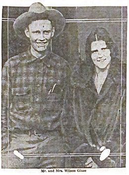
On February 21, 1928, the couple was married 5-weeks after she purchased the bridal and 3-years after Barbra having arrived in Colorado. He was 27 and she was 23 and they were said to be madly in love and to have a romance that “bloomed rapidly”. The Colorado Springs Gazette and Telegraph reported that their relationship was “love at first sight between one of New York's best-known debutants and heiress to millions and a bronzed giant cowboy of Colorado Springs”. They went on to say it “culminated in a wedding that gave Gotham something to gasp over”. The ceremony was shrouded in secrecy and only close family members attended the small gathering in the Monell home. Barbara intentionally registered for their marriage license using her Colorado Springs address rather than her New York City address, to avoid raising media attention ahead of the ceremony. It took the local paper a full 10-days before they realize and reported on the uncommon marriage.
Barbara's father had little to say regarding his daughter's choice of husband. But he did deliver an ultimatum to her on her wedding day. Reportedly saying “if she were to marry again, he would disown her”.
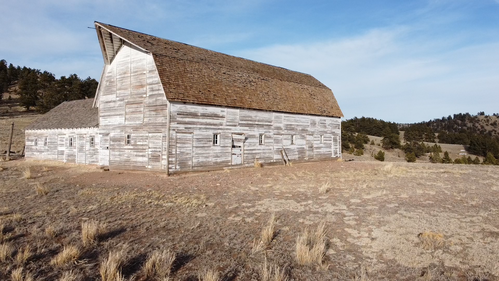
Shortly after their marriage, a local man named Franklin Nash recalled Barbara negotiating with his father (W. Nash) to purchase six head of registered Herford cows. According to Franklin, Barbara did not want her husband (Kenneth Wilson Glaze), to know she was purchasing the cows. That same year: in 1929, they had the Gambrel roof barn built, which stands nearly 100 years after its construction. I speculate that the purchase of the cows was an attempt to make the construction of the barn a necessity. Regardless, Barbara's ranch was very elaborate for the inter-war period in this area of Colorado, because most ranchers of the era could not afford an investment of this scale. 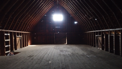
In a 1999 interview a local woman; Ruby Ankrum-Werley, spoke about some of her times on the ranch when she was 20 years old. Rudy had resided in Fremont County since 1931 and recalled when Barbara Glaze moved to the house on what was at the time called the “Skyline Ranch” or "Green Mountain Ranch". Ruby attended Barbara’s housewarming party in 1934. During the party, one guest spilled a glass of wine on another guest. Without hesitation, Barbara took them to her closet and told the wine-soaked guest to choose any dress they like. It was a gift to the guest; however, Barbara had little need for the multitude of fancy dresses that she owned. This is because she never wore them. Ruby stated that Barbara preferred to wear trousers and men’s style lace shoes. She elaborated by saying, “in the 1930’s women always wore long dresses, so Barbara Glaze was quite a gossip among the local women”.
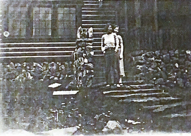
 The Monell-Glaze Home The Monell-Glaze Home
Nearby newspapers reported on the housewarming party and the home, saying, “the beautiful mountain home of Mrs. Barbara Monell-Glaze… The home built of logs was recently completed and opened at the housewarming to which many Canon City people were invited. The home contains 11 rooms and three baths. A two-car garage in the basement houses her Rolls-Royce and Auburn cars”. In other words, this house sported a size and amenities that were not common in most American homes at that time. 18-20 years after its construction, in the 1950s, it was common to see homes of this size, with attached garages. I suppose Barbara had Architectural tastes that were ahead of her time. The home she built was in sharp contrast to the other homes in Guffey Colorado. It was described as “the finest of its kind in the state”. She made a splash with the locals by bringing her own breed of Park Avenue flair to Southern Colorado.
 Barbara In Her Living Room Barbara In Her Living Room
The article went on to describe an immense living room with two fireplaces, plush leather seats, and built-in bookshelves. The walls were lined with fine beads and animal skins. But this was not what Barbara choose to showcase during the interview, she led the reporters to the front entrance. Where just outside sat her dog kennels and an opportunity to share with the community another one of her hobbies, raising huskies/sled dogs.
This housewarming party was just the first of a regular series of ‘open houses’, or what we would call today, house parties. Residents from the area were said to dance the night away and eat what was called a “midnight lunch”. Or in other words, they partied all night and had a late-night meal. Barbara’s party dress was described as “Canon City Trousers, a shirt open at the neck, Indian moccasins, and a jaunty tam (or beret)”. Her close friends would joke that she was just a “regular guy”. 
Unfortunately, the romance and good times did not last, and they were divorced in 1931. The headlines read, “Marriage of Heiress and Harness Maker May End in Divorce Court”. However, to get divorced at that time was not that easy, especially for a woman. This is because the accuser was required to prove they had grounds for divorce. Which in most cases came down to a case of he-said-she-said. There was no guarantee that the courts would grant a divorce. It’s no wonder so many people who faced a lengthy, arduous, and uncertain divorce opted to go to Reno Nevada. Where they advertised themselves as the “divorce capital of the world”. This is because they had an expedited divorce system, that after only 6-weeks of residency, they could rubber-stamp a divorce in minutes. Fortunately for Barbara, had the means and wherewithal to establish residency in Reno. In March of 1931, she announced that she intended to establish residency in Reno for the purpose of initiating a divorce.
 Kenneth W. Glaze & Kenneth R. Glaze Kenneth W. Glaze & Kenneth R. Glaze
The firstborn son of Kenneth, Kenneth Richard Glaze; recalled in a 1999 interview that Barbara gave the ranch to his father after the divorce in 1932. But according to his recollection, his father lost the land one year later to what he called “fraud paperwork by Colorado Springs lawyers”. His last recollection of Barbra was that “she was living off on Highway 115” with a new lover, “Bob Ford”. He went on to say that “they may or may not have been married”. Which I can imagine only added fuel to the townsfolks' gossip and the Manhattan-based scandal.
However, it seems the fraudulent paperwork that Kenneth R. Glaze recalled was legitimate. This is because shortly after the divorce Barbara Glaze sold the ranch to Jim Luthi on October 22nd, 1932. Meaning; Kenneth W. Glaze would have been evicted from the land. 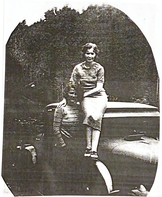 Barbara Monell-Glaze & Cleota Dunbar-Bell Barbara Monell-Glaze & Cleota Dunbar-Bell
During the same year, an unlikely friendship was started between Barbara, and a young lady named Cleota Dunbar-Bell. The friendship blossomed rapidly and added to the townsfolks’ speculation that Barbara was a homosexual. To add to the evolving town scandal Cleota was only 18 years old and Barbara was 32 years old, literally twice Cleota’s age. Regardless of the locals’ suspicions that was a large age gap for a friendship or relationship, especially at that time. Cleota had attended Barbara’s barn dances multiple times and had been acquainted with Barbara for some time. Even though Cleota had spent several nights visiting with people in the “big log house” she did not find herself in the same social circles as Barbara.
 Barbara & Cleota 1932 Barbara & Cleota 1932
They were not formally introduced until Barbara moved to Canon City and began shopping at the Canon City drugstore, where Cleota worked as a clerk. Barbara had become a regular at the store after having purchased a home on the corner of 7th and Main (in Canon City). Cleota recalled Barbara pulling up to the drugstore in her Rolls Royce, being freshly divorced, and being the “talk of the town”. On December 28th, 1932 Cleota was married to a man named George Bell and her friendship with Barbara faded as the time came to pass. Little was heard of Barbara Glaze in Guffey or Canon City after this. She did resurface, for a time, in Denver Colorado. She was remarried and Barbara’s father kept his word and disowned her. Unfortunately, she was last seen in 1935 driving a beer truck in Denver.
31 Mile Ranch found its way into the hands of a man named John Robinson, who owned the ranch for much of the 1940s. He held parties for school children in the barn. In a 1998 interview one of the students, Rose May White; talked about her times on the ranch, as a 6-year-old who attended his parties. She mentioned a time when a friend of hers fell from a horse and broke her pelvis. Shortly after this incident, the ranch was sold for a time to a gentleman named Louis Greer. It was during his tenure on the land, where we lost the home built by Barbara Monell-Glaze.
 Wilbur & Larraine Sigler In Front of Their New Home Wilbur & Larraine Sigler In Front of Their New Home
Later in 1950; the ranch was acquired by Wilbur and Larraine Sigler. They Purchased 3,000 acres for $10 per acre. This purchase equates to $335,097 in today’s currency, which even with that lens on is a particularly good deal. The 5-room log building that was built by the original settlers served as a temporary bunkhouse for the Sigler’s. It remained this way for a decade, until 1960; when Wilbur Sigler had the existing and modern house built by a man name, Mr. Lafferty. The house features a stately, yet rugged fireplace that was handcrafted with local field stones, by a gentleman named Wilbur Earhart. The home is built with a traditional tongue and groove log cabin style and the timber came from the nearby town of Howard Colorado. The home was powered by a modest 110-volt Onan Generator that sat in a shed behind it. It was supplied water by a spring that sat just a quarter-mile up Paris creek. Three years later Wilbur commissioned local men; Bob and Don Ankrum to construct a pond outside the front door of the cabin. Setting the tone for a picturesque mountain retreat that remains in place to this day. Wilbor and Lorane lived in the house during the summer months, where they raised cattle. During the winter, the home and ranch were left to the elements as the Sigler’s returned to their Permanent home in Boone Colorado. The couple sold the land in 1977 and continued to lease the ranch until 1989.
 Mr. R.W. "Curley" Reynolds with Kathie Moore, of the Park County Historical Society Mr. R.W. "Curley" Reynolds with Kathie Moore, of the Park County Historical Society
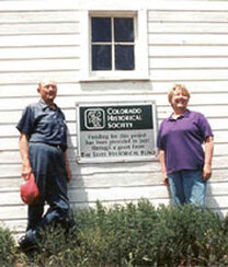
Eventually, 31 Mile Ranch and its surrounding lands were acquired by the Bureau of Land Management. This is where it remained for 7-years until late 1999 when Mr. R.W. "Curley" Reynolds acquired the property through a land swap with the Bureau of Land Management. Upon receiving a grant from the State Historical Fund in 2000 and providing a 50% cash match, he undertook a majority of the repair and restoration work on the barn, the windmill, and log cabin. The exterior cladding of the barn was repaired, new wood shingles were installed on the barn and cabin. Additionally, the ground around the barn and cabin was regraded for better drainage. The windmill was repaired by replacing a single blade. Additional labor was provided by the Park County Historical Society, which gave considerable effort to this project.
Today the home, bunkhouse, and surrounding property is a rental location. Popular with hikers, photographers, wildlife enthusiasts, and people who are looking to escape the busyness of their day-to-day. The beautiful landscape combined with the old-world-ranch charm makes 31 Mile Ranch one of the most authentic Colorado experiences you can have. If you are looking to step back in time and get away from it all, I highly recommend booking a trip to 31 Mile Ranch. You can find information on how to book your mountain get-a-way using the links below: Photos From The Day:Potential EVP Recorded At 31 Mile Ranch (members only): Click HereMusic From The Video:
One of the best sounds school-aged kids hear is when the last bell in the last class rings signaling the school is out for summer. In the words of Alice Cooper, “Out for summer. Out til’ fall. We might not get back at all.”
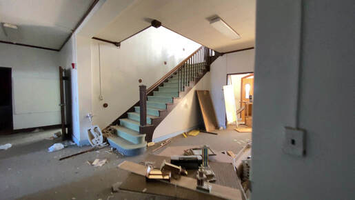
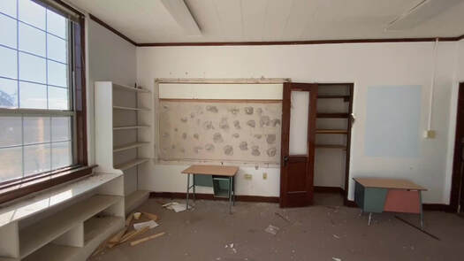
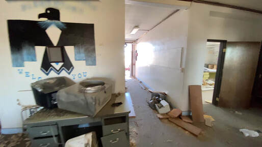
Today I would like to visit one such school. Where school was let out for summer and never returned. The once busy school halls and classrooms are deserted and desolate. At one time these halls were filled with laughter, the playground filled with joy, and the gymnasium roared with cheers. 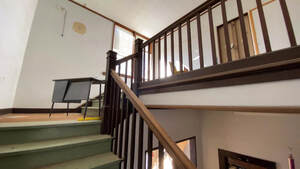
School closures are something we are all too familiar with in the United States. Mostly impacting older buildings, urban areas, and low-income regions. For example, the capital of the rust belt; Detroit, with its rising crime, diminished population, reduced manufacturing jobs, and decay is an ideal environment for school closures. Over the past decade, more than 30 schools have permanently closed their doors in Detroit alone.

Other cities such as Chicago, Philadelphia, and New York have shut hundreds of public schools. But, this is not isolated to a few areas, every place in the country sees schools merge, consolidate, or close entirely. Regardless of the city size, make-up, or region the decision to close a school is never taken lightly. The school systems are trying to work through an ever-shrinking pool of funding and lack of political support. Causing a cycle of closures and community mistrust that further deepens the political gap.

There are many factors that contribute to school closures and to be clear schools are not closed without a suitable replacement being available. One of the most common reasons a school closes is due to maintenance costs. For example, schools took on millions of dollars of renovation costs, when we were ensuring no asbestos or led-based paint was used in new or existing construction. In some instances, it was more cost-effective to close the school and build a brand new and more efficient building. In that instance, the structure simply outlived its usefulness and had become a health concern. Sometimes they close because the demand for education far exceeds what the current structure can accommodate. In the case of private schools, it is nearly always a funding issue. Other times schools close due to shrinking enrollment and dwindling population. In this instance, the remaining school-aged children are bused to a large regional school. Which is the case of the school we are having a look at today.
However, an American school is much more than a slab of brick-and-mortar that kids attend during the day to learn; for most families, they act as community centers and gathering places. When a school is closed; especially in a small town, people often feel a sense of upheaval and grief. Not to mention a feeling of uncertainty that arises towards their local governments' commitment to equitable education. In 2014 four independent education organizations in New Jersey, Illinois, and Louisiana filed a complaint. In which they asked the US Justice Department and Department of Education to investigate discriminatory practices through the school closings. The resulting investigation concluded that it was a matter of low tax income and overall school funding. Meaning; low-income areas were impacted the most by the school closures; due to lack of funding, not the ethnicity of the local population. Regardless, of the investigation's findings and whether it was intentional; it leaves our minority community without the education centers and gathering places that are afforded to more affluent communities. The fraught debate continues, but at the end of the day, many of the pain points that communities are going through would be solved by increasing public school funding.

Setting the economic struggles of the school system aside: Artists, poets, and filmmakers have long realized the emotive power of this struggle and its abandoned institutions. The closures are set against the backdrop of numerous shuttered schools and derelict playgrounds. Ushering in a new era of urban explorers and documentarians. Carrying a tradition that dates back to the 18th-century, when French painter; Hubert Des Ruin painted derelict structures. Later in the 20th-century, conceptualist painters recognized that abandoned buildings can show us complex social issues. A little later the husband and wife team Hilla and Bernd Becher became well known for their depiction of abandoned industrial era facilities across Europe and North America.

Another example of this includes a 1974 project by Gordon Matta-Clark that famously photographed an ordinary structure in the suburbs of New Jersey that was awaiting demolition. Later Nicolai Ouroussoff; a New York Times architecture critic, said about the photos, they gave him a “growing sense that the American dream was evaporating”. A few months later, the home was demolished. Now a growing group of contemporary artists is expanding on the concept that abandoned schools can be more evocative than a derelict factory or homes that are slated for demolition. An abandoned school and its remnants are more personal, poignant, and relatable. They represent a collective childhood experience as much as they represent a deeply private experience.
Typically, there are two approaches in this field of art. For one, there are artists who document the sorrow and frustration felt by the students, teachers, and community (commonly referred to as urban explorers or Urbex). Next there are the artists who practice a form of art called “social practice”. They tackle policy issues and ask direct questions related to the waste of abandoned structures. While urging residents to reimagine abandoned schools and openly engage with city leaders.
Regardless of the approach, there are many possibilities for abandoned art as a catalyst for social change. A drastic example of this is a demonstration staged by Ai WeiWei, arguably the world’s most famous activist. He used over 9,000 backpacks to spell out the sentence “She lived happily in this world for seven years” on the side of a Munich museum, criticizing the Chinese government after thousands of students died when their shoddy classrooms collapsed during a 2008 earthquake. Piles of dead children's backpacks were found at the sites of the demolished schools. Today Ai’s exposure of China's shoddy construction practices is credited for the policy changes that the Chinese government eventually made. This new commitment to a safe schoolhouse left many Chinese areas with abandoned schools. While the changes we see in the US are much less drastic; the heart of the matter and goal is the same, to ensure a safe and productive school environment. 
Back in the states, we have much more stable school buildings; however, distance is becoming a problem. For example; in Chicago, evidence shows that closures have forced children to cross through gang territory to get to their newly relocated schools. In 2013 the Chicago Teachers Union president; Karen Lewis questioned whether the additional security costs outweighed the estimated $1 billion the district saved in closing 49 schools. A cost that is significant when you consider private security forces, as well as the Chicago Police department, now protect the children's commute to school. Again, this problem boils down to a lack of funding to the school system, but in this case, it comes with an increased security burden. A burden that added costs to the school system in a manner that does not provide educational resources or support, just basic safety.

A few years ago, a Baltimore based advocacy group called the Teachers’ Democracy Project posed a simple question about school closures: “Why would we close any small, safe, and relatively successful school, particularly if it is located in a low-income, Black neighborhood and serves as a vital anchor-institutions?”. The hard truth is the closures have to do with fiscal circumstances and lack of public support. Politicians, educators, and reformers all have competing views and approaches to “solving” the problem. There is no direct evidence that closing makes it difficult for educators, but there's a plethora of evidence related to the impact on our children. For example; students living in low-income regions are five times more likely to drop out than those from wealthy and middle-class areas. And identifying at-risk students is best done with small class sizes and an ongoing relationship with the teachers and students. Both of these things are prevented from happening when we close a school and overcrowd another school (to take on the new student base). Because the closings are more often in economically struggling communities, the students could; over a period of time, perpetuate the high dropout and imprisonment rates that plague their communities.
There is a simple solution to all of this. One that we have turned a blind eye to for too long. We must fund our schools more and fill them with motivated and well-compensated educators. For the richest country in the world to act like we can’t manage this simple task is laughable. The pentagon alone spends $746 billion a year. That’s over $62 billion a month and over $2-million a day. If we were to shave one-tenth of this funding and give it to education we would have 746 million dollars. This is enough money to fund every public school, stock them with new supplies, and adequately compensate our educators. We could even fund our community colleges in a manner that makes them free and public institutions. While the pentagon's funding is a drastic example, it demonstrates that it is a lack of prioritizing our education and children. It’s not that we do not have the funds and resources to improve our schools. It’s a lack of desire and political support. The lack of appreciation for public education will only leave us with a wider economic gap, overcrowded schools, and a poorly educated population. Sadly, the saying “you get what you pay for” applies all too well to this situation.
Soundtrack By: Ⓢ | Ⓡ | Ⓖ
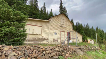
The former townsite of Apex Colorado is nestled into a shadowy, narrow, and windswept valley. Only a few of the city's buildings remain today and few people come to visit. It’s best viewed after the winter snow melts off the roads and Pine Creek is flowing behind the former main street. April or May is an ideal time to avoid snow and for viewing wildflowers and wildlife.
During my visit I spoke to an elderly gentleman who claimed to be the last resident of Apex; however, he also gave me instructions for the best places and methods for BigFoot viewing. He is the self-proclaimed mayor and sees himself as the watchmen of the land. Considering the source, he did have some interesting facts about modern-day Apex that were not cryptozoology related and was able to show me some of the gems in this hidden valley. Today I would like to share with you some of what he showed us during our journey while expanding upon the history of Gilpin County Colorado and Apex.
When making your way up Apex Valley road and entering the townsite you will see very few buildings but will notice the tree line has been pushed further away from the road. Giving way to lush meadows and a view of Pine Creek. While it may not seem like it, you have entered the former city. With the exception of several buildings, the Meadows are all that marks the land where Apex Colorado stood. Today it can be hard to imagine over 1,000 settlers living in this valley. The valley is not very hospitable with the aid of modern technology, let alone over a century ago.
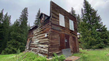
One of the most noticeable buildings is a swaying false-fronted building. This building boasts a large brass medallion that lists it as the first site (Site #001) in the Gilpin County Historical Society Register. The Juxtaposition of the new and heavy brass affixed to an old and fragile building is striking. The marker indicates a desire by this organization to preserve the structure. And this is made evident by the temporary buttresses that have been added to brace the building from falling. Many people would look at this structure and assume that it cannot be saved. However; I have seen larger and worse off structures that have been brought back from this condition. You can see an example of a similar building being brought back from the brink in my Ohio City video and vlog. That said; this particular structure in Apex Colorado served as a hotel and boarding house during the city's boom period, the 1890’s.
The area was first prospected by, Richard Mackey in the 1870s when he stumbled on an outcropping of gold. Shortly after his claim was sold, and resold until a man named “Mountz” purchased the claim as a partner. In need of money, Mackey sought a partner and found it in Mountz. After clearing out the easiest to reach gold and making $30,000, Mackey vanished. Shortly thereafter Mountz ran out of money again and began to live in squalor. Weary and upset, he planted his last two sticks of dynamite at the mine opening with the intention of closing it off. The next morning as he ate his last bit of food and prepared to leave, he noticed the shattered pile of debris from his explosion was all gold ore and behind the ore-pile was an exposed vein of Gold. Mountz once again stumbled onto Gold, but this time he found an extremely rich vein of Gold. This claim became known as the “Pine Mining District''. This load was the largest acquisition in the area and produced ore at a value of $1,800 a ton. Which in today's value would equate to $110,500 a ton. Mackey’s find continued to produce ore and it justified the creation of a mill in the town, this was a rarity for a community of this size.
The Colorado Bureau of Mines; in a 1919 report, describes the community of the Apex mines:
“The Pine Mining District, six miles north of Central City, is where the Evergreen Mines Company properties are located. During the fall and winter of 1917 and 1918, they erected a 100-ton flotation mill, which is equipped with electric power. This company gives employment to a great number of men year-round. The Pennsylvania and Colorado Mining Tunnel and Milling Company's mines and mills are located in this district and several other smaller properties.” 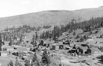
With such valuable ore, the mining camp quickly blossomed into a city and was established as a town in 1891. It’s worth noting that this was 30-years after the nearby communities of Central City and Nevadaville were established. This means that many prospectors combed through these mountains during the Gregory Gulch Goldrush and were not able to find gold. But thanks to the patience of Mountz, Apex continued to grow until the early 1900s.
A small cluster of cabins and sandy streets is all that remains of a once-bustling metropolis that served as the Capital of the Pine Creek Mining District. A newspaper from the nearby town of Idaho Springs reported throughout the boom years and produced several photos of the town's construction. At its peak, it featured over 80 businesses downtown and housed over 1,000 residents in the surrounding community. Although the railway never made it to town, several stagecoach lines ran from Nevadaville and Black Hawk. The stage line brought with them a daily stream of mail; which was a luxury for most mining communities. They had several saloons, a dance hall, grocery store, hotels, a schoolhouse, and eventually, its own post office. It operated intermittently from 1894 to 1932. 
The districts’ mining companies were well represented on the main street, with multiple offices dotting the street. By 1897 the town achieved its next milestone by producing its own weekly newspaper, called “The Apex Pine Cone”. The first volume was printed on July 3rd, with the intention of the first run being ready to read on Independence Day (July 4th).
Like many of the communities in this mining district, it did not have a cemetery of its own. Rather they choose to inter their residents in the nearby Central City Cemetery. Which created a massive set of cemetery plots in the nearby town of Central City. Despite being a substantial mining town, the lack of a cemetery makes it difficult to discover details of the town and its citizens. Unfortunately, some of the most interesting details of this wealthy mining town are lost to history. 
It took its architectural secrets and history to the grave when Apex lost large swaths of buildings over the course of two separate wildfires. Much of the business district was destroyed and we are left with only the open meadows we see today. The residential areas of town have been reclaimed by the woods and are mostly collapsed. Except for a handful of cabins, illegal mining operations, and homes.
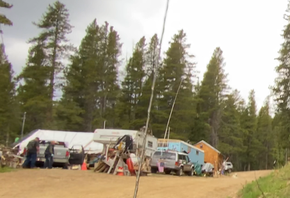
Apex is mostly abandoned, with the exception of the aforementioned “Mayor” and his “visiting kin”. I had the pleasure of speaking with the Mayor and although it was hard to get a word-in with him, I was able to get his permission to record our conversation. This was of course only if I agreed to hear him out about his tall tales of espionage, Nicola Tesla’s ongoing work in Colorado, radio waves in his teeth, and his uniquely insane worldviews. As you might be guessing, this man is as crazy as they come but is generally harmless and well-intentioned. He is extremely verbose and can be found on the top of Elk Park road in a set of trailers that are surrounded by snowmobiles and ATVs. Do not seek him out, but if you are lucky enough to meet him and decide to engage with him in conversation, be prepared to spend 20-30 minutes chatting.

While the Mayor is about as friendly of a schizophrenic as you’ll find, his dog, “Dummass”, is not. This white Pyrenees dog guards the mayor and his property with extreme prejudice. He feels like it is his job to direct traffic and he personally owns the road. Don’t be surprised if Dummass attempts to herd you or your vehicle away from the Mayor's property.
Photo from the Day: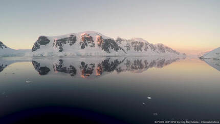
Few places on earth have the same sense of adventure and discovery as the Rocky Mountains. With the exception of the Alps, Andes, Himalayas, and of course Antarctica. In this article, I would like to momentarily divert my attention from the Rocky Mountains to the vast frozen continent of Antarctica.
People have been desperate to understand and explore Antarctica since its tentative discovery by Captain Cook in the 1770s. Eventually, his sighting was confirmed by Fabian Gottlieb von Bellingshausen in January of 1820, when he saw the Antarctic ice shelf. By 1840 the Wilks expedition established that Antarctica was indeed a continent. Nations fell upon themselves to begin to understand, explore, and lay claim to this harsh and frozen wasteland. 
Early explorers used the methods of Native Americans to explore the Antarctic Ice shelf. Specifically, they borrow techniques from the Inuit People of Alaska; such as sled dogs and thermal-insulated clothing. However, food was scarce and these methods would not sustain the explorers very long. In order to explore deep into Antarctica innovation and invention were required.
Each successive expedition and encampment brought with them experimental equipment and techniques. All designed to better explore and conquer the unforgiving and otherworldly environment of Antarctica. Innovation would not prove easy; specifically, early vehicles and motorized equipment had a very hard time in these conditions. 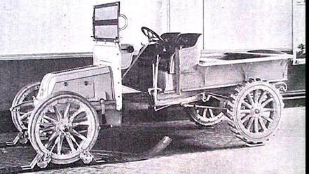
Automobiles were still in their infancy during early explorations and to this day equipment must be specially designed to withstand and operate in constant sub-zero temperatures. Each attempt to introduce vehicles to the difficult landscape and temperatures suffered faults, fails, and numerous setbacks.
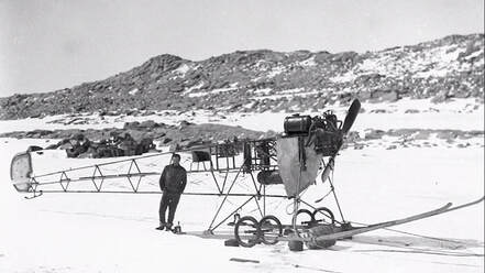
British explorer Ernest Shackleton in the Nimrod expedition managed to bring the first automobile to the continent in 1909. The expedition boasted a specially designed vehicle that was donated by the defunct British automaker, William Beardmore and Company. The vehicle replaced the front tires with skis and the rear tires with large cogs. It was ultimately unsuccessful in navigating the deep snow and ice. For that matter, it could not be started at sub-zero temperatures or run for an extended period of time in the cold. Like most things in Antarctica it was repurposed and was reused as a wagon. For the remainder of this expedition, they relied on traditional sleds. 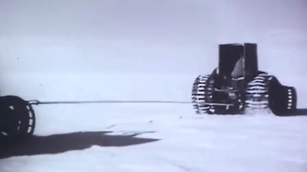
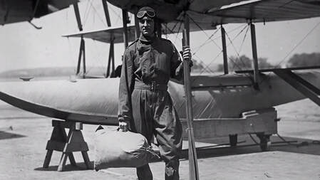
One year later; in 1910, a British Naval officer named Robert Falcon Scott saw potential in Ernest Shackleton’s idea and further innovated upon this concept during the ill-fated Terra Nova expedition. He and his engineer Reginald Skelton pioneered and advanced the concept of motor-driven sleds during their race to the south pole. But they later abandoned the idea for a caterpillar track to make it across snowy surfaces. This innovation edged us closer to something resembling the workings of a modern snowmobile.
By 1911 Australian explorer Douglas Mawson set his sights on Antarctica. During his visit to the continent, he intended to bring the first airplane. Unfortunately, the plane crashed during an airshow demonstration before Mawson ever left for the expedition. Making the best of a bad situation and ever-the-showman, Mawson had the plane hastily reconstructed into what he called an experimental “air-tractor”. This was basically a tractor on skis, made out of the old Vickers airplane. This was also unsuccessful. The engine was removed and sent back to Vickers, in England. The rest of the plane was abandoned and claimed by the arctic snowdrifts. Similar to the motorcars, sleds, and vehicles that came before it. But these failures are not uncommon and it is only through failure that science can learn what does or does not work. As they say, “the road to success is paved in failure.” or “Fail fast and learn slowly.”
Flash forward 20-years to the 1930s Antarctica was to be home to one of the most incredible and ambitious vehicles ever built. The Arctic Snow Cruiser was impressive not just in its incredible size and innovative features but was also notable as an automotive masterpiece.
But before the Arctic Snow Cruiser could make its way to Antarctica the groundwork was laid by Rear Admiral Richard Evelyn Byrd Jr. from the United States Navy. Byrd is most well known for his successful flights over both the North and South Poles. Although his claim to the North Pole flight was later disputed by the Smithsonian Institute. None-the-less he was an accomplished arctic explorer who was a part of the crew who completed the first transatlantic flight in 1919. Eventually, Richard Byrd was the recipient of the Medal of Honor, which is the highest honor of valor given by the United States. 
Through the 1920s Byrd had been organizing American expeditions into Antarctica. He had established two bases on the continent; “Little America” (in 1929) and “Little America II” (in 1934).
By the end of the 1930s war was threatening to engulf the world as World War II was ramping up. Germany as well as the Japanese empire were increasing their activities and territorial ambitions around the continent of Antarctica. Because of this president, Roosevelt sought to make the US presence in Antarctica permanently established. 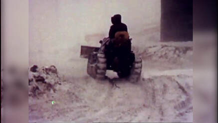
Roosevelt’s increased interest in the continent drastically improved Richard Byrd's third expedition to the antarctic. It grew out of it’s small and privately funded roots into a well-funded mission. One that looked to maintain United States bases on both sides of Antarctica. It was organized jointly by the US Department of State, The US Navy, The Department of the Interior, And the US Department of War. The base was named “Little America III” and demonstrated the United State’s interest and dedication to the arctic. A spirit that continues to this day.
This was the largest expedition the world had seen so far and nations waited with anticipation to discover the final scale of this grand expedition. However, few could guess what innovation was about to roll onto the stage. This is because Byrd and his team drew from the past experiences and failures of the equipment used and sought to design a vehicle that could incorporate the best elements of its predecessors. He had considerable success with caterpillar tracked vehicles in his previous expeditions. In fact, he credited their use directly for saving his life when he had been stranded alone in a remote outpost, during his second expedition. 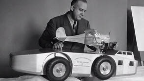
Byrds deputy, Dr. Thomas Poulter has spent the years since researching ways to adapt the motorized tractors they used to be better suited for sustained use at sub-zero temperatures. Working with the Armor Institute of Technology; in Chicago, now the Illinois Institute of Technology, Poulter designed what he called “The Snow Cruiser”. His design was a 55 feet (16.7 m) long, 25 feet (7.6 m) wide, 37-ton giant. It was designed to have a range of over 8,000 miles (12,874 km) and could sustain a crew for up to a year on the ice without resupplying. The monstrous machine was powered by two specially designed diesel-electric engines and was designed for a maximum speed of 55 miles per hour.
The Snow Cruiser was crammed with clever innovations; such as its four 10-foot tall balloon-like Goodyear tires. The tires and wheel assembly could be moved individually and lifted clear of crevices and other obstructions. Additionally, they could completely retract them into the chassis of the cruiser. Add to that, the tires had an innovative system that was designed to keep the rubber of the tires warm, by reusing the heat and exhaust from the engine bay.
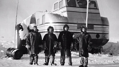
Inside the Snow Cruiser featured all of the facilities a crew of four could need for exploring and living in the Antarctic landscape. It was complete with a control room, a machine shop, a galley, a dark room, extra tanks for fuel, food storage, crew quarters, and it even had space for two gigantic spare tires. The range of gadgets and capability were nearly endless. 
The top of the Snow Cruiser sported a cradle for an aircraft. The plane boasted a range of about 300 miles (482 km) and acted as a scout for the cruiser. The aircraft could be loaded and unloaded through the sloped back of the cruiser.
This was without a doubt the most ambitious vehicle of its time. But before it could be built it was up to Thomas Poulter to justify how this vehicle would revolutionize arctic exploration. Eventually, the US gave the Snow Cruiser project the green light and handed over $150,000 a value of $2.3-Million at that time. 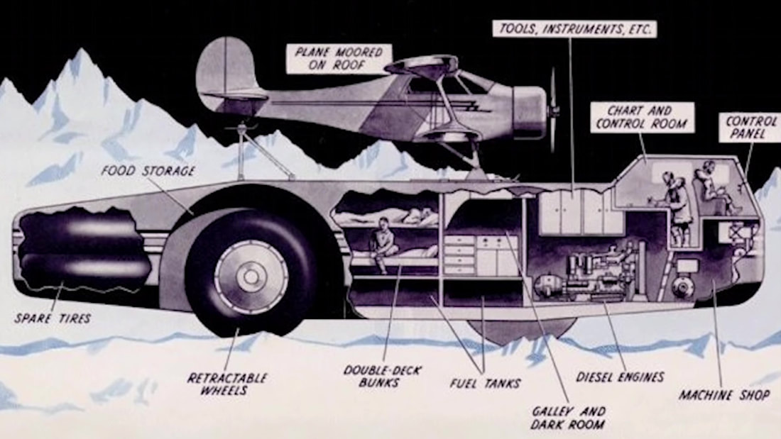
The Snow Cruiser was seen by the US congress as the crown jewel of an arsenal of new tools they looked to deploy in what was now the United States' fourth expedition to Antarctica. Especially because other countries' interests and competing claims to the region began to pick-up. While the cruiser was being built Germany had deployed a large catapult ship to the region and begun to operate survey planes around Antarctica. “Claiming” large tracks of land in the name of Nazi-Germany.
In an effort to further impress upon Congress and justify the large expedition budget Poulter began to boast about how the craft was designed to cover 500,000 square miles during an Antarctic summer. A claim that was a bit sketchy, but plausible nonetheless. With the international competition now worrying lawmakers, the Antarctic Snow Cruisers construction was expedited. 
It created a national sensation as it raced off the factory-floor and across 1,000s of miles or roadways. Making its way from Chicago Illinois to Boston Massachusetts. At the time the Cruiser was wider than most of the nation's roads. To navigate around this, they executed a carefully orchestrated plan which involved closing highways and clearing traffic from the roadways ahead of the Snow Cruiser. It was a parade-like atmosphere, a sensation that was driven home by the motorcade of police that both preceded and followed the massive automobile. At one point the cruiser attempted to navigate over a creek and did get stuck for a time. While this was not a very encouraging moment, the engineers used this as an opportunity to test the independent suspension in a warmer climate.
None-the-less it made it back onto the roadway and to the Boston docks on time, where it was loaded onto the supply ship, “The North Star”. Along with Food, spare tires, several tanks, prefabricated huts, and everything they would need to live for over a year in Antarctica. In order to fit the vehicle, the entire rear-wheel section was removed and stored elsewhere. Once this was completed it was secured to the deck of the North Star. The captain had concerns about the weight being distributed properly, but after Byrd's insistence, they permitted the cargo aboard. With much fanfare the North Star and Arctic Snow Cruiser inches into the Pacific Ocean. After a few nervous moments, the captain gave his approval and set sail in November of 1939. 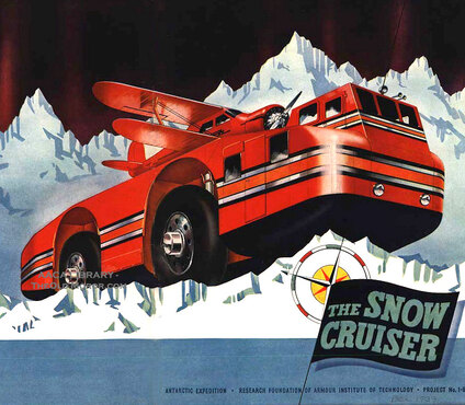
As it made its way, the New York Times surmised that: “The Snow Cruiser has connected West Base with East Base; or has rolled along that coast which no man has surely seen… or, perhaps, made itself a laboratory-based, for a period of months, at the Pole itself”. Only a few of their hopeful claims would come to pass. While it may have been a bit presumptuous of the New York Times, it goes to show just how enthusiastic Americans were about the Snow Cruiser.
The expedition reached the site of little America III in January of 1940. As the Arctic Snow Cruiser made its way off the North Star and on to a simple wooden ramp. The ramp began to give away. Leading to a tense moment when Byrd was nearly thrown from the roof of the cruiser. Fortunately, Byrd was able to run to a handhold and secure himself. Meanwhile, Poulter, who was at the wheel hit the accelerator, leaping the cruiser forward and on to the relative safety of the ice. 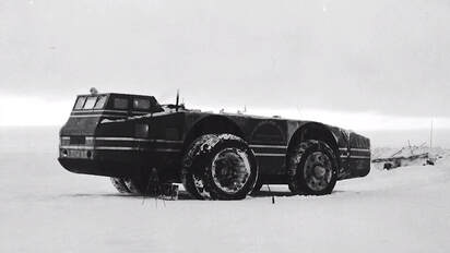
Once on the ice, they found that the vehicle was much slower than anticipated. To correct this issue, they outfitted the Snow cruiser with two spare tires for additional traction. But this design change gave way to a new problem, it was now very bouncy. In fact, it earned itself the nickname, “bouncing Betty “. Additionally, the vehicle was already at its maximum design weight. With the added weight the innovative diesel-electric drivetrain was now underpowered. Interestingly, they found that in this configuration the cruiser was fastest in reverse. So, they simply started driving it backward. However, the prospects for long-range travel didn't look good and the crew was forced to abandon these efforts.
Making the best out of the situation, they used the airplane to survey large sections of the ice shelf that Little America III rested on and was able to scout into the continent.
While it’s primary purpose was not successful, it did find success as a stationary laboratory and served as the most luxurious and modern crew quarters on the continent. The innovative heating system and insulation material proved to be very effective and was integrated into future projects. However; the great Arctic Snow Cruiser was forever assigned as a stationary part of Little America III. This is how it remained until the western base was decommissioned in 1941. The entire base was evacuated later that year as the concentration of troops and funding moved to defend the world from the increasing German, Japanese, and Italian aggression. At that time the Arctic Snow Cruiser was buried with snow and abandoned. 
After World War II, In 1946, during an American expedition called “operation high-jump,” the team located the abandoned base and the giant snow cruiser sitting exactly as it had been left. The team of explorers said the vehicle was in remarkably good condition. Saying “only air in the tires and a basic servicing would have had it up and running again”. However; nothing further was done and the Arctic Snow Cruiser was once again closed up and left to the elements.
In 1958 the cruiser made its final appearance on the world stage. This time it was an international expedition that completely uncovered the snow cruiser from its tomb of ice using a bulldozer. It was hidden under several feet of snow, but a long bamboo pole left by the previous expedition still marked the location of the Snow Cruiser. Inside the cruiser was again reported to be exactly how it was leftover two decades ago. Complete with newspapers, magazines, and cigarettes still placed as if waiting to be picked back up. This group of explorers was likely unaware at the time, but they were the last people to see the incredible Arctic Snow Cruiser. 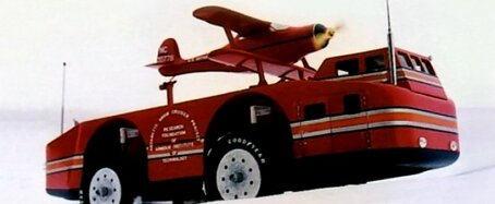
Or were they? Could it be possible that the snow cruiser is still sitting under the snow and ice of Antarctica? Somewhat recently a team located pieces of Douglas Mawson’s “air-tractor”. They were discovered under 9 feet of ice (3 m). Relics from old expeditions are found regularly to this day. Many of these items are preserved by the sub-zero temperatures and ice encasement. Some feel that the Soviets may have recovered the Snow Cruiser after it was unearthed in 1958. While this is very plausible, it is unverifiable and remains just a theory. So to answer my question, “Could it be possible that the snow cruiser is still sitting under the snow”? This is likely not the case.
This is because in February of 1963 a US Navy icebreaker ship spotted an unusual streak of brown amongst the blues and whites of passing icebergs. As they edged closer they were amazed to find what appeared to be the remains of Little America III protruding from the iceberg. The ship launched its helicopter to take aerial photos. It even landed on the iceberg in an attempt to access the base. Ultimately they were unable to find a way in, however; they could clearly make out the remains of tents, fabric, and prefabricated huts. Huts that were strikingly similar to huts that Byrd used during his expeditions. The icebreaker was able to verify that cans of food and equipment were still neatly packed on the shelves; much like the team who visited Little America III in 1958 described. Five telephone poles and antenna fitting still stood above the snow. Notably, two bamboo marker poles were still in place on the surface. 
It is a safe assumption that the ruins found by the Navy were that of Little America III. With that assumption taken into account, it means that the majority, if not all of the base has broken off the Antarctic ice shelf and has drifted away into the ocean. We do not know what part of the base that iceberg held, but it is entirely possible that one of those bamboo markers stood over the buried Arctic Snow Cruiser. It has likely drifted out to sea and eventually sunk to the sea bed. Though, a part of me doesn’t accept that this was its fate. I still hold hope that one day she will emerge jutting out of an old iceberg or maybe parched on the side of the Ross ice shelf. Perhaps it will be dredged up from the seabed by a commercial fishing operation. One thing is certain though, despite its failure to connect the East and West bases it succeeded at igniting the American spirit, imagination, and most of all innovation.
|
AuthorThank you for visiting! This is a collection of media from the lost and abandoned corners of the world. Please have a look around, I hope you enjoy. Archives
April 2022

Categories
All
|
Libraries |
Support |
|